Industries
The campsite map, the document nobody can read
A site plan answers the manager's question, not the holidaymaker's. What an aerial view changes about booking a pitch.
On arrival Saturday, between eleven and one, the same conversation plays out at almost every campsite in Europe. A holidaymaker comes back to reception, map in hand, and asks to change pitch. They are in full sun, or too close to the path, or four hundred metres from the pool with two children.
They were not misled. They booked from a map they thought they had understood.
A site plan answers a manager’s question
The document pinned up at reception and published on the website is a site plan: a schematic view from above, numbers, coloured zones, a key. It answers perfectly the question of whoever commissioned it - where are my pitches, how are they numbered, where do the services run.
It answers none of the holidaymaker’s questions, which are all questions of distance and atmosphere: is there shade at two in the afternoon, can you hear the road, how steep is the slope, how many minutes to the shower block with a three-year-old.
That information exists on the ground. It simply cannot be represented by a number or a block of colour.
campsites in France, Europe's largest stock
7,362
Ten times the number of golf facilities. And of those 7,362 sites, the overwhelming majority sells its pitches with a site plan and two photos of the pool.
What an aerial view says that the plan cannot
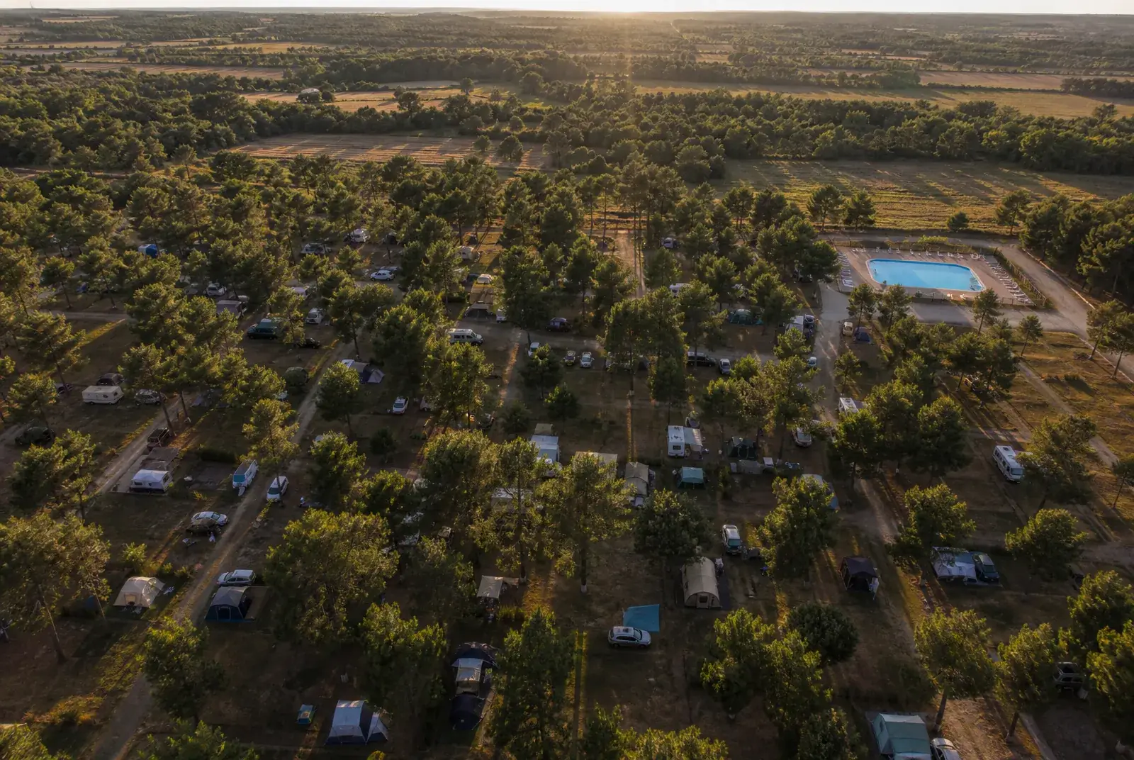
From thirty metres, distances become readable again because they are seen rather than represented. You take in at one glance that the shaded zone is the furthest from the shower block, that the pool backs onto the restaurant, that pitches 40 to 60 run along a hedge that screens the road.
That is exactly what an aerial virtual tour gives, and it is the one thing a site plan will never give.
The same information, two media
The site plan
Numbers
pitch 47 exists, it is in the green zone, it is 100 m² - and nobody knows what that means
The aerial view
Distances
pitch 47 is under the pines, two paths from the pool, backing onto the hedge that screens the main road
The holidaymaker is not looking for a photo, they are trying to place themselves
That is the nuance that decides everything, and it explains why adding photos solves nothing.
A photo of a pitch shows a square of grass. Ten photos of pitches show ten squares of grass, and the holidaymaker still does not know which one is near what. What they are missing is not imagery, it is a map to put what they see onto.
It is also what separates a tour designed for a campsite from a tour designed for a flat. In a flat you move from room to room and the movement is enough to understand. On three hectares that movement teaches you nothing: you have to place things first, then look closely.
What it changes, concretely, for the manager
Three effects, in the order you notice them.
Requests to change pitch fall. A holidaymaker who has seen where their pitch lands before booking arrives with the right expectation. That is so many fewer conversations on a Saturday in July, and so many fewer reallocations.
Neglected zones start selling. A pitch “down the back, by the hedge” sells badly on a plan. From the sky it becomes “the quietest, in shade all afternoon”. That is not spin: it is the information that was missing.
The argument shifts from price to place. As long as the holidaymaker sees only a rate card and a site plan, they compare prices. The moment they see the ground, they compare holidays.
What to show, and in what order
Six to twelve viewpoints are enough for a campsite of normal size. The order counts as much as the number.
The wide shot first. It places the site in its surroundings: the sea, the forest, the village, the road. It is the scene that answers “where exactly is this”.
Then one view per zone. Every pitch zone has an identity - shaded, open, sloping, on the edge. One scene per zone, and the holidaymaker can finally choose.
Facilities last. Pool, restaurant, play area, shower blocks. Those are the photos everybody already has; their value here is being placed where they belong on the map, not being beautiful.
And the inside of the rental units goes into the same tour: the engine displays any spherical panorama, whether it was taken thirty metres up or inside a lodge. Aerial is the speciality, not the limit.
The plan does not disappear, it changes role
It stays useful - at reception, for operations, for the emergency services. What it stops being is a sales argument.
A site plan says what the campsite contains. An aerial view says what the stay will be. They are two different documents, and only one of them makes people book.
The campsite pack brings together the industry template, the map of the grounds and an introduction to a drone pilot. To compare the market’s platforms on a campsite’s criteria, our guide Campsite virtual tours: 7 solutions in 2026 covers the ground.
Développeur et télépilote de drone. Construit Moorea au sein d’Elvn Studio.
Further reading
 Drone & capture
Street View: what Google closed, and what it left open
The app went in 2023, the photographer programme in 2024, the publishing interface stayed. What those three dates change for anyone selling 360 capture.
6 min read
 Engineering
One camera, three surfaces: flattening the world in 360
Why the edges of a 360 panorama stretch as you zoom out, which projections fix it, and why all three fit in one line of shader.
7 min read
 Drone & capture
How sharp does a virtual tour need to be?
Megapixels say nothing about the sharpness of a 360 panorama. The only metric that counts is angular density, in pixels per degree.
5 min read
A place worth showing from above?
The free plan is enough to publish a first tour and show it around.